


ECUADOR MOUNTAIN CLIMBING
AND
TREKKING TOURS
MOUNTAINS IN ECUADOR
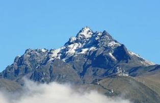
Corazon - 4788m
Chiles Camping, 4768m
Puntas, 4450 m.
Altar, 5404m
Guagua Pichincha, 4794m
Sincholagua, 4919m.
Cotacachi 4939m
Morurco Camping 4880m.
North Iliniza, 5116m.
Pichinchas Integral
Cayambe Volcano Summit, 5780m.
Corazon - 4788m
TECHNICAL LEVEL: Average
PHYSICAL LEVEL: Average
DEPARTURE TIME: 06H00
ESTIMATED RETURN TIME: 20H00
We will travel south passing through the town of Machahi until we reach our start walking point. We will begin walking for approsimately 5 hours to the summit at 4780m. passing beautiful scenery and unforgetable views. Come back to the transport and return to Quito.
Chiles Camping, 4768m
TECHNICAL LEVEL: Average
PHYSICAL LEVEL: Average
DEPARTURE TIME: 06H00
ESTIMATED RETURN TIME: 20H00
Located on the Ecuador/Colombia border. On the return we will fresh ourserlves with a exquisite bath in the hediond waters.
Puntas, 4450 m.
TECHINICAL LEVEL: Average
PHYSICAL LEVEL: Average
DEPARTURE TIME: 05H00
ESTIMATED RETURN TIME: 20H00
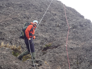
Puntas Mountain is found within a less-frequented zone in the western Andean Mountain Range on the border of the Cayambe-Coca Ecological Reserve. This unique mountain has various beautiful summits, whose tallest peak reaches heights of 4.460 m / 14.632 ft. We will travel for approximately 2 hours to the Checa Hacienda from where we will begin hiking through the moor to the base of the rock wall, where we will climb 20 m / 66 ft. to reach the summit.
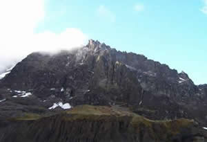
Altar, 5404m
TECHINICAL LEVEL: Average
PHYSICAL LEVEL: Average
DEPARTURE TIME: 05H30
ESTIMATED RETURN TIME: 20H00
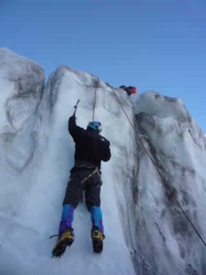
Is an extinct volcano and after it had an immense eruption centuries ago it has now the shape of a horseshoe. The volcano is open on one side and its very sharp peaks reach high up into the sky - a truly amazing scenery! The vertical walls of the volcano are covered with glaciers.
Guagua Pichincha, 4794m
TECHNICAL LEVEL: Medium
PHYSICAL LEVEL: Average
DEPARTURE TIME: 06H00
ESTIMATED RETURN TIME: 20H00
Guagua is an indigeneous word that means "baby" and it is an historic mountain because in its skirts Quito's independence was sealed definitely. We will climb to the top enjoying the spectacular views of Quito while working for acclimatization. We will be able to observe great samples of paramo vegetation including pink ladys fingers and high-altitude bromeliads in this area. Return to Quito in the late afternoon.
Sincholagua, 4919m.
TECHNICAL LEVEL: High
PHYSICAL LEVEL: High
DEPARTURE TIME: 06H00
ESTIMATED RETURN TIME: 20H00
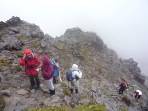
It is a less frequently climbed thatn any of the other mountins. Early departure from Quito trough the South of the Panamerican Highway. We will arrive at the departing walking point. During the walk, you will cross Páramo vegetation, sandy slopes and rocks. From the summit, you will have a magnificent view of Cotopaxi, Rumiñahui and back side of Pasochoa.
Cotacachi 4939m
TECHNICAL LEVEL: High
PHYSICAL LEVEL: High
DEPARTURE TIME: 05H00
ESTIMATED RETURN TIME: 20H00
The Cotacachi Volcano is located at the Western mountain range, being an integral part of the "Cotacachi-Cayapas" Ecological Reserve. To reach the summit, which lies at 4,935m (16,200 feet), the climbers must have some experience in rock climbing and be guided by a professional climber.
Morurco Camping 4880m.
TECHNICAL LEVEL: High
PHYSICAL LEVEL: High
DEPARTURE TIME: 05H00
ESTIMATED RETURN TIME: 20H00
Morurco is a small mountain behind Cotopaxi, one of our active vulcanos here in Ecuador. climbers must have some experience in rock climbing, however if you do not have experience, we will hike around its skirts as well.
North Iliniza, 5116m.
TECHNICAL LEVEL: Medium - Hight
PHYSICAL LEVEL: Average
DEPARTURE TIME: 05H00
ESTIMATED RETURN TIME: 20H00
Early departure from Quito we will take the Panamericana South highway until we arrive to El Chaupi village and then to La Virgen where we will start the trek up to the refuge Nuevos Horizontes 4,600m. We will continue hiking to the top of Illiniza North 5,116m. The first trails are sandy mixed with rocks while closer to the top the terrain is rocky. The area is normally dry, however at times there is light snow covering. Despite what it may sound, the level of the climb is easy and fun. Back to the refuge and then the return to Quito.
Pichinchas Integral
TECHNICAL LEVEL: Low-Average
PHYSICAL LEVEL: Hight
DEPARTURE TIME: 05H00
ESTIMATED RETURN TIME: 20H00
From North to the South, four summints in one day: Sara Urco 4,676m, Ruco Pichincha 4,680m, Padre Encantado 4685m, Guagua Pichincha 4,794m
Cayambe Volcano Summit, 5780m.
TECHNICAL LEVEL: Hight
PHYSICAL LEVEL: Hight
DEPARTURE TIME: 09H00
ESTIMATED RETURN TIME: 16H00
The Cayambe is the only volcano in the world whose summit is crossed by the equator. As the third highest peak in Ecuador, Cayambe was only first conquered in 1880 by Edward Whymper and the Carrel brothers. However, it is most renown for having the largest and arguably the most beautiful glaciers in Ecuador. For adrenaline junkies these huge ice plateaus also offer skiing opportunities at 5.500 m. This mountain belongs to the National park Cayambe-Coca. Due to its technical difficulty, it is less visited than other mountains, despite its close proximity to Quito. For those who do reach the summit.
ECUADOR MOUNTAIN CLIMBING TOURS
Corazon - 4788m
Puntas, 4450 m
Altar, 5404m
Guagua Pichincha, 4794m
Sincholoagua 4919m
Cotacachi 4939m
Morurco Camping 4880m
North Iliniza, 5116m.
PICHINCHAS INTEGRAL
Cayambe Volcano Summit, 5780m